A few yers ago, the Border Road Organisation gave the Indian motorcycle community a new adventure trail — Lipulekh Pass on Kailash Mansarovar Road.
I attempted a motorbike trip on this route, the very first year this route was under construction (in 2020) and put my name in the history of the first few motorbikers who attempted it. No one, at that time, except for the Indian army and the locals from village Garbiyang (whose residents reportedly own land around Kalapani), had accessed the newly built Kailash Mansarovar Yatra Road and reached Lipulekh Pass. At that time, it was the Kailash Mansarovar road route was closed for the general public in India.
Check out my video below (a real vlog) of my journey back in 2020..
Today, the Kailash Mansarovar Road Project, a very ambitious project by the currently-in-power BJP government with the instrumental involvement of Nitish Gadkari, is open for adventure enthusiasts.
Kailash Mansarovar Road Project
The Kailash Mansarovar Road Project stands as a monumental initiative aimed at enhancing connectivity to the sacred and remote region of Kailash Mansarovar in Tibet, China. This ambitious undertaking seeks to establish a road network that facilitates easier access for pilgrims and tourists to reach the revered Kailash Mansarovar Lake and Mount Kailash, one of the holiest destinations in Hinduism, Buddhism, and Jainism.
The significance of the Kailash Mansarovar Road Project cannot be overstated. KAILASH MANSAROVAR ROAD, previously accessible only through arduous treks or long and challenging routes, will become more accessible, allowing pilgrims and travelers to embark on their spiritual journeys with greater ease and safety. This initiative also aims to boost tourism in the region, thereby fostering economic development in the local communities.
Central to the success of this project is the instrumental involvement of Nitish Gadkari, the Minister of Road Transport and Highways of India. As a key figure in India’s infrastructure development, Gadkari has played a pivotal role in advancing the project. His commitment to improving road connectivity has contributed significantly to the realization of this ambitious endeavour, emphasizing his dedication to facilitating easier access to KAILASH MANSAROVAR ROAD.
Other than that, the route will serve as a very scenic and adventure-thrill location for the motorbiking and 4*4 off-roading community in India.
In conclusion, the Kailash Mansarovar Road via Lipulekh Pass holds immense relevance in providing…
- improved access to the sacred region of Kailash Mansarovar,
- a scenic and a very adventurous route for the off-roading enthusiasts
- a strategic defence route with China Border
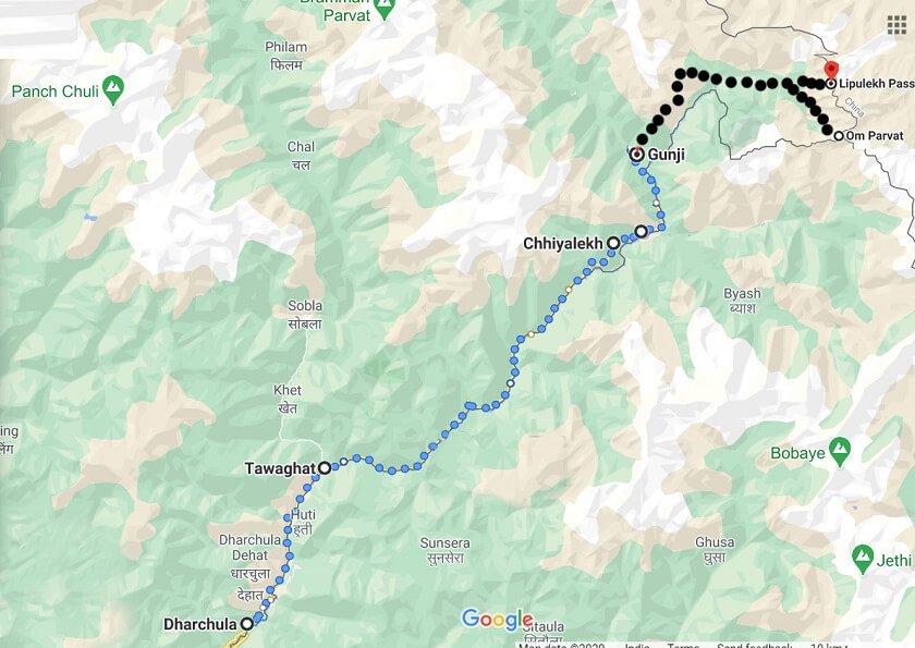
The same Kailash Mansarovar motorable road can now take the tourists all the way from Dharchula to Om Parvat and Adi Kailash in just a few days.
Until now, it was only possible to reach Lipulekh Pass, Adi Kailash and Om Parvat after a nearly 10-day trek from a place called Budhi. Dharchula to Budhi was a 50km or a 3-hour drive. From Budhi (about 5 km before Chiyalekh, or Chhiyalekh) it was a narrow trekking route to Om Parvat, Adi Kailash, and other places.
If we trek to Adi Kailash it takes nearly 13 days for someone to reach from Dharchula to Adi Kailash base camp trek (near Jolingkong) and return.
Since the Kailash Mansarovar road has opened for tourists, it takes less than half the total time to reach Om Parvat, Adi Kailash and Lipulekh Pass. It, moreover, is possible to enjoy this scenic route our own vehicle — all it will take is an Inner Line Permit from SDM in Dharchula.
My First Unsuccessful Attempt…
In the first week of October 2020 I, along with a few other riders from Pithoragarh and Dharchula tried to access Kailash Mansarovar road up to Lipulekh Pass.
We started from Dharchula and rode all the way to Chiyalekh. At Chhiyalekh, since we did not have the Inner Line Permit (issued by SDM Dharchula) we were stopped by the ITBP and asked to return to Dharchula.
In October 2020, given Indo-China border tensions SDM Dharchula was not issuing ILP to tourists to access the route. Why? Other than China, Nepal is also objecting to this newly built Lipulekh Pass road, and this has triggered tensions in the border areas.
Kailash Mansarovar Road Itinerary: Via Lipulekh Pass
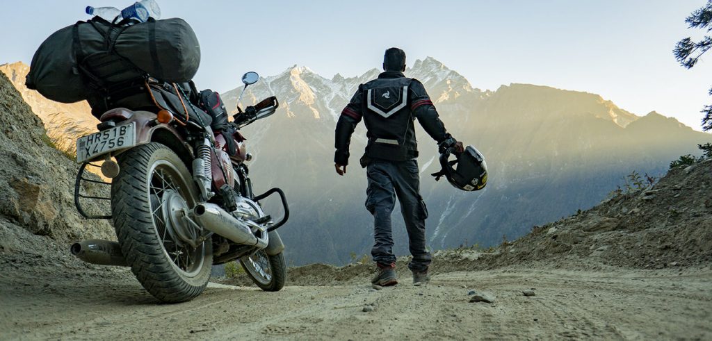
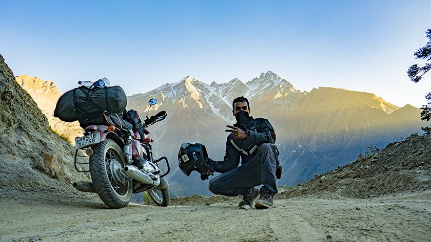
After the unsuccessful attempt in 2020, I reattempted this rote in 2026. This newly built motorable road by BRO (border road organisation) is by far the most adventurous motorcycle route. It is next level to Shinkula Pass in Zanskar and Sach Pass in Chamba, forget Spiti Valley or Manali to Leh highway.
The first 20 km (Dharchula to Tawaghat) is a mix of concrete and dirt road, and the next 35 km (Tawaghat to Budhi) is only a dirt track. The real adventure began after Budhi, which, for Chiyalekh, was in fact only 5km but take you more than 2 hours.
From my estimate, it climbs over 500m within 5km. One hairpin bend after the next on what was nothing but a dirt track carved out of blasted mountains. “And it is just the beginning,” I was told. “The real adventure lies after Chialekh”.
It is at Lipulekh Pass, on the newly built Kailash Mansarovar Road, that India concludes its territory to Tibet (now under China).
As per rough estimates, this is how the distances on this newly built road looks like:
- Dharchula to Gunji via Chialekh (72 km)
- Gunji to Nabhidang to Lipulekh (18+11 km)
Just like how we did during our ride, I suggest you also leave Dharchula in the morning and reach Chiyalekh (located 13 km before Gunji) on day 1. Do the same for the rest of the days as it’s highly adventurous route.
Here’s a more detailed 5-day itinerary to complete the Kailash Mansarovar Road trip…
- Day 1: Dharchula – Tawaghat – Pangla – Najang – Malpa – Budi – Chiyalekh Top (3180m) – Garbyang (3044m) – Ceti (2915m)
- Day 2: Ceti – Napalchyo – Gunji (3128m) – Kalapani Temple(3505m) – Nabidhang (4119m) – Gunji (3128m)
- Day 3: Gunji – Nabi – Kuti (3736m)
- Day 4: Kuti – Jolingkong (4295m) Gauri Kund (4493m) – Lipulekh Pass (5200m) – kuti – Nabi
- Day 5: Nabi – Gunji – Garbyang – Najang – Dharchula
If you are coming from Delhi, add two more days for Delhi to Dharchula, and back!
What Kind of Vehicle Should You Drive
If you are driving: Though I saw a few 4*2 Mahindra Boleros struggling the way, I strongly recommend a 4-wheel drive for Lipulekh Pass on Kailash Mansarovar Road.
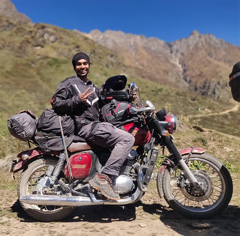
Two Wheelers: As far as motorcycles are concerned, I suggest something that is quick and nimble. For me, for example, my Jawa 42 did a perfect job. Its lightweight body, powered by a 300cc and a 28 N.m @5000 rpm of torque generated enough power to easily climb uphill.
We had other motorcycles like a couple of Royal Enfield Classic 350 (that I’ve always found too bulkier and heavier for such terrains, including Ladakh and Spiti Valley), a Hero XPulse and a Royal Enfield Himalayan, and I found my Jawa 42 doing better than all of them thanks to its great power output.
Having said that, as long as your motorcycle has a great power output and is not too heavy, given its engine size, you should do good on those roads. It’s not necessary to have a big engine (a 200 or 300 cc should do fine) but for a motorcycle trip to Lipulekh Pass on Kailash Mansarovar road, your bike should have enough torque to be able to pull you through.
If you don’t know Mount Kailash, located in China occupied in Tibet, is of high religious significance to Hindus in India. For ages, Hindu and Buddhist pilgrims have been making an arduous journey to this place.
The Mansarovar Lake, a freshwater body fed by the Kailash Glacier, is believed to absolve all sins with a sip.
The newly-made Kailash Mansarovar Road will cut down the travel time of this arduous journey, which was, in fact, only possible on foot and horseback so far, by nearly 80 percent.
Also Read Panchachuli Base Camp Itinerary in Darma Valley (the road for Darma Valley bifurcates from Tawaghat, near Dharchula). It is possible to visit Lipulekh Pass and Darma Valley in a single visit to Dharchula.
If you have a question or would like to connect, please find me on Instagram. You can also follow my YouTube channel for video updates.